SD VISta Nature Framework Public Consultation Launch
This article is an automatically translated version of the original Japanese article. Please refer to the Japanese version for the most accurate information.
This is Sustainacraft Inc.'s Newsletter (Special Edition).
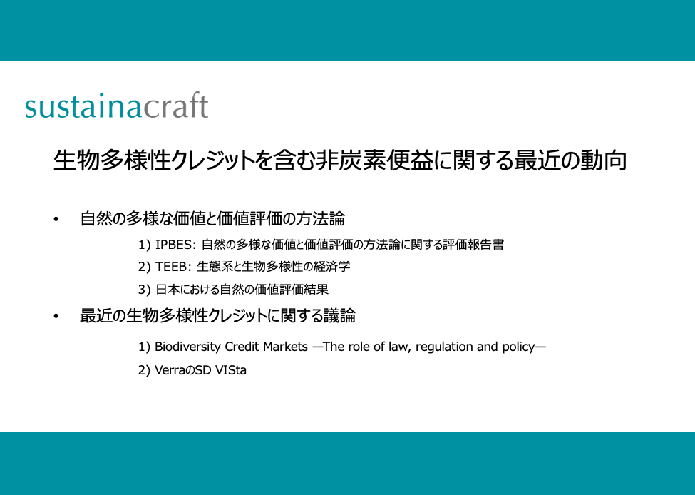
This time, we introduce Verra's highly anticipated Nature Framework for biodiversity credits, which has just opened for public consultation. Our initial impressions of the current draft indicate it has been developed with two key considerations:
(1)Reflecting all recent discussions on Carbon Credits (e.g., introduction of the Consolidated Methodology approach for REDD baseline setting, clarification of stakeholder engagement and safeguard requirements).
(2)Terminology aligned with TNFD (Taskforce on Nature-related Financial Disclosures).
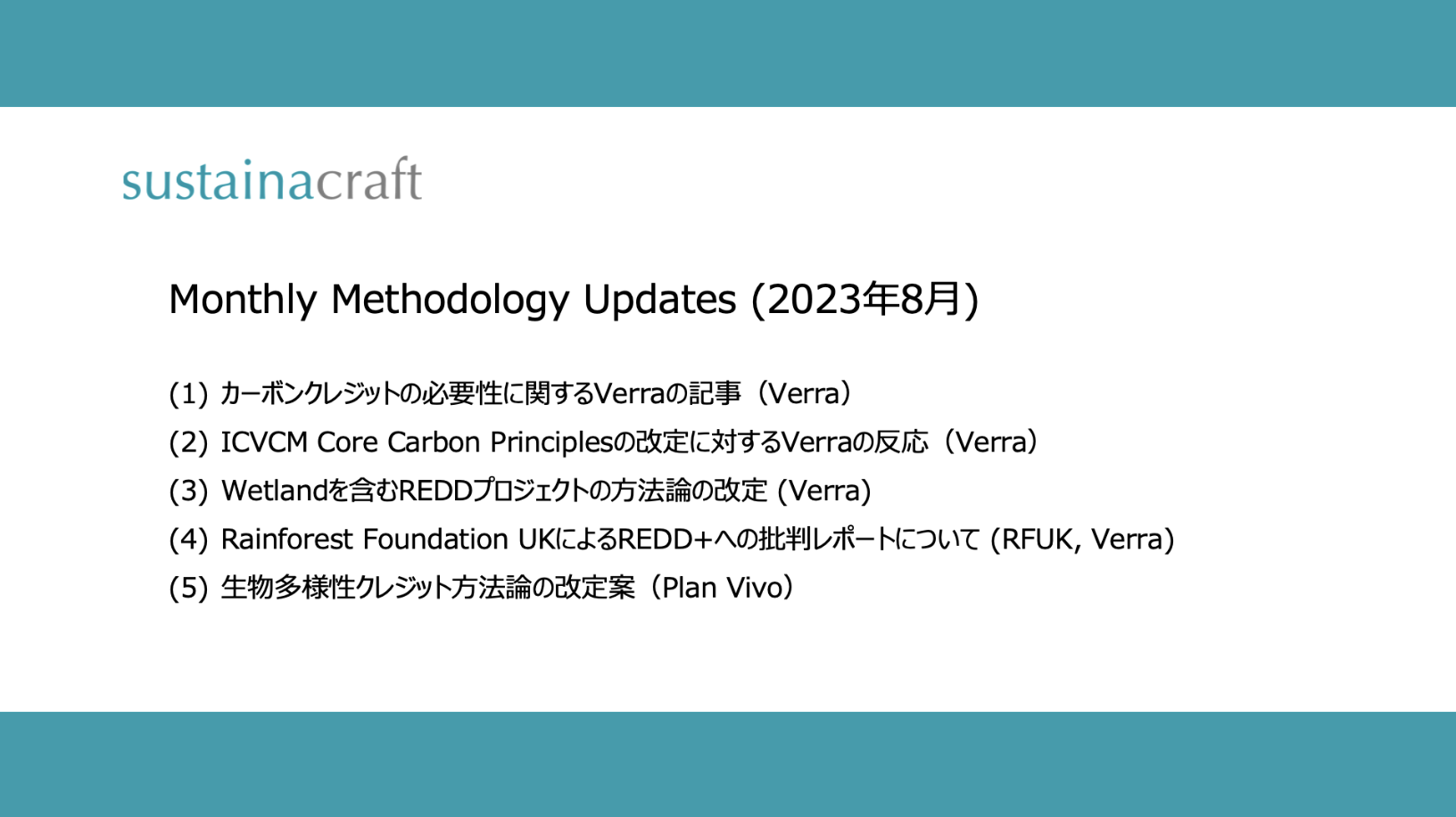
For more on biodiversity, please refer to the articles below. While the second article discusses Plan Vivo's biodiversity credit Methodology, which does not consider Avoided Loss and sets the Baseline at zero, Verra's framework places significant importance on Avoided Loss. Consequently, it provides detailed guidelines for defining the Baseline (referred to as "Reference Condition" in alignment with TNFD terminology). Furthermore, learning from recent criticisms of REDD, it adopts an approach based on a Consolidated Methodology to prevent arbitrariness.
Verra recently called for pilot demonstrations for this Nature Framework. Our company also applied in collaboration with other organizations, but unfortunately, we were not selected. It seems there were nearly 200 applications, and 18 projects were chosen.
This article is publicly available. You can subscribe for free using the button above. If you wish to subscribe to paid articles, please consider subscribing using the button below.
Nature Framework (Verra; SD VISta)
(link)
Overview (From 1. Nature Framework Introduction)
The underlying philosophy of this framework is summarized in "1.3 Key Nature Framework Design Objectives." Here are a few points:
2. Establish a balance between standardization, to allow for comparability across projects, and flexibility, to account for project’s local ecological and social context.
A major difference from Carbon Credits, which target carbon benefits, is that for biodiversity, there is no unified metric, and the local characteristics of each project must be considered. However, a certain degree of standardization is necessary for Methodologies. Therefore, an approach that balances individuality and standardization is proposed. Specifically, this Nature Framework itself is composed of two parts: the Nature Framework and Ecosystem or biome-specific modules, with the latter still under development.
5. Support conservation of ecosystems at high risk of biodiversity loss.
As mentioned at the outset, preventing future biodiversity loss is crucial, and therefore, Avoided Loss is also eligible for Credits. Similar to the "avoidance vs. Removal / Sequestration" debate in Carbon Credits, the same argument is being discussed for biodiversity. Unlike Plan Vivo, which excludes Avoided Loss, this framework emphasizes Avoided Loss, reflecting Verra's perspective, which is largely dominated by REDD.
6. Build on the lessons of voluntary carbon markets.
This refers to the point mentioned at the beginning regarding "lessons from REDD." The Baseline is stated to be created by a third party (not the Project Developer / Proponent) based on the ecosystem condition of the entire ecoregion, similar to Jurisdictional REDD Baselines. This point will be elaborated on further below.
7. Reward long-term stewardship of nature, even where there is no imminent threat.
This appears to be analogous to HFLD (High Forest, Low Deforestation) in Carbon Credits. That is, areas that have been well-managed for a long time without Credits often cannot Issue a sufficient number of Carbon Credits under the conventional Carbon Credit framework due to a low Baseline Deforestation rate. However, this is actually the result of long-term efforts and should be appropriately valued. The Nature Framework states that such "nature stewardship credits" will be included within the Nature Framework, but as a separate asset from other activity types. As an example of an activity, OECM (Other Effective area-based Conservation Measures) is explicitly mentioned. As OECM's Nature Co-existence Sites selection progresses in Japan, this could become a powerful incentive design.
Requirements (From 2. NATURE FRAMEWORK PROJECT RULES AND REQUIREMENTS)
This section defines several requirements, including project duration, start date, and Additionality. Of particular note are items 2.7 and 2.8 below, which are aligned with the recently revised VCS Standard ver4.5, as introduced in the article below.
2.7 Safeguards for Biodiversity Outcomes
2.8 Safeguards for Sustainable Development Benefits
Quantification (From 3. QUANTIFICATION OF BIODIVERSITY OUTCOMES)
This section describes how the quantity of biodiversity Credits is specifically quantified.
First, it is important to understand the following BECS (Biodiversity Extent, Condition, and Significance):
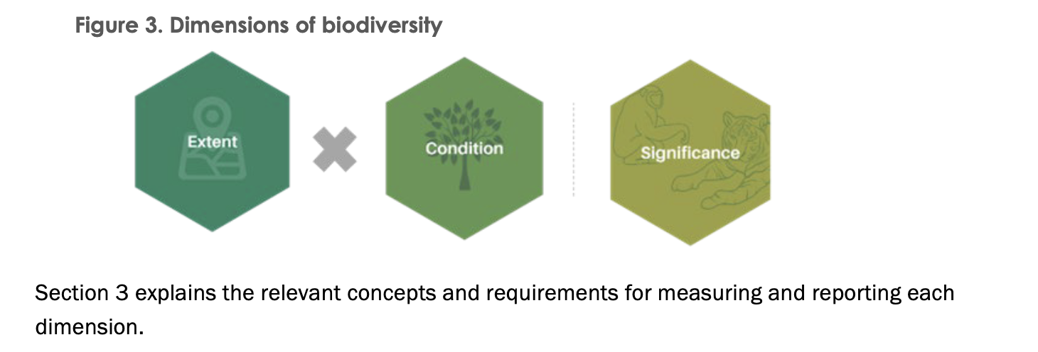
Extent is area (hectares), and (Ecosystem) Condition is an indicator showing the quantity and quality of biodiversity. The unit for biodiversity Credits is Qha (Quality Hectare), which is the product of Extent and Condition. This Extent and Condition are indicators that form the Ecosystem component of the State of Nature in TNFD, demonstrating alignment with it.
Significance, on the other hand, indicates the importance of the location's biodiversity and is used to differentiate Issued Credits, but it does not affect the amount of Credit Issuance (Qha). This is a significant difference from Carbon Credits. It is thought that Significance provides criteria for Buyers to judge what specific biodiversity improvements (including Avoided Loss) they are contributing to, within the context of Qha as a standardized metric. Examples of Significance include targets set by the GBF (Global Biodiversity Framework).
The overall approach to quantification is shown below:
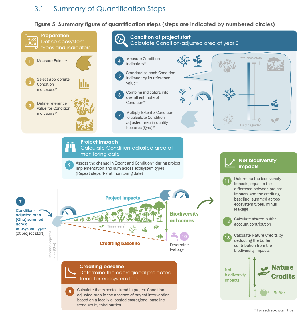
<Preparation>
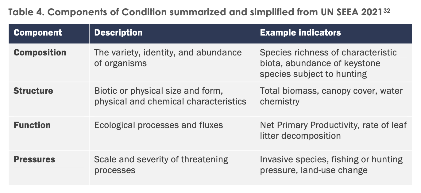
Selection of Condition indicators: This begins with selecting Condition Indicators. Four are shown in the table below, with Composition and Structure being mandatory to measure, requiring at least two and three indicators, respectively.
Setting Reference State Values: For the Condition Indicators set above, values for a **reference state** are defined. The reference state, as described in the "Method for the Establishment and Survey of Reference Sites for BioCondition" published by Queensland, Australia, which this Framework references, represents the original, undisturbed natural state:
A regional ecosystem in its reference state is refers to a stable state that is mature and long undisturbed, or Best on Offer (BOO), given few ecosystems are totally free of impacts of threatening impacts in the contemporary landscape
(From Method for the Establishment and Survey of Reference Sites for BioCondition)
Determining reference state values while considering local contexts for each project is technically difficult and requires Verification. Therefore, the possibility of an approach where a third party sets standardized values for each ecosystem type in an ecoregion, which projects can then use directly, is outlined for the future. This approach seems to seek to minimize project-specific arbitrariness, also in consideration of recent discussions on Carbon Credit quality.
<Condition at project start>
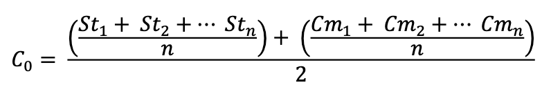
Quantification of Condition at Project Start (and any subsequent point): Each indicator for condition is standardized on a scale from 0 to 1. A value of 1 represents the reference state, and 0 represents a completely degraded state. There are two types of indicators: (1) indicators that decrease with degradation, such as Biomass or species richness, are simply calculated as `[Value of current state] / [Value at reference state]`, and (2) indicators that increase with degradation, such as the number of invasive species, are calculated as `(T - [Value of current state]) / (T - [Value at reference state])`, where T is a threshold value representing a completely degraded state.
As mentioned above, multiple indicators are set for Composition and Structure. For each, a normalized value ranging from 0 to 1 is calculated using the above approach, and these are simply averaged to converge into a single indicator representing the state at a given time. The following formula calculates the state at time t=0 (project start), assuming n number of structure indicators and composition indicators:
Multiplying this value by Extent (area) calculates the **Condition-adjusted Area**, an indicator with the unit "Quality hectares."
In fact, this line of thinking aligns with the concept of MSA (Mean Species Abundance), an indicator introduced in the article below, and the proposal for a uniform indicator called "MSA・km^2," which multiplies MSA by area1.
<Crediting Baseline>
Setting the Baseline: This is the section of the framework expected to generate much discussion and was considered "based on lessons from REDD," as mentioned at the beginning. The current proposal outlines an approach where the overall trend is first estimated at the unit of CECs (Country Ecoregion Components), which are considered ecologically and politically homogeneous. This overall trend is then allocated to 1km² grids within the CEC, and the project-level Baseline is calculated from that.
This is precisely the same direction as the large-scale REDD Methodology revision currently being implemented, representing a standardized approach that avoids arbitrariness on the part of Project Developers / Proponents. Its intention is clearly stated as follows, so we will quote it directly here2:
A standardized ecoregional approach is proposed instead of a project-by-project approach for setting crediting baselines. This draws on the lessons of REDD projects and is proposed to promote integrity of the crediting system as a whole. Verra’s new consolidated REDD methodology uses a two-stage approach to establish crediting baselines for avoiding unplanned deforestation. First, information on recent forest loss is generated for an entire jurisdiction (a country or sub-national administrative unit). This provides a prediction for jurisdiction-level forest loss in the upcoming crediting period. Second, relative deforestation risk is mapped across the jurisdiction based on proximity to observed recent losses. Combining this mapping with the jurisdictional baseline allows allocation of an appropriate crediting baseline to each project.
(From 8.2.1 Overall approach)
However, for REDD, the only indicator to observe was forest cover. For the Nature Framework, additional discussions are needed on whether global datasets are available for various ecosystems (terrestrial vs. marine, and different terrestrial ecosystems), and how to reflect their condition. Against this background, while the default is the globally standardized approach described above, it is also stated that unique local approaches (applicable only within that ecoregion) can be used if condition changes can be measured with high accuracy.
Even within a single CEC, some project areas may have higher or lower risks. The overall CEC value is allocated to each grid according to the risk of that specific location. Regarding this risk-adjusted allocation, until a tool is finalized, forest projects can use the risk mapping tools developed for REDD. For other projects, initial participants may set project-specific Baselines using covariates such as distance to urban areas or roads, and elevation.
<Supplement: About CECs (Country Ecoregion Components) and Ecoregions>
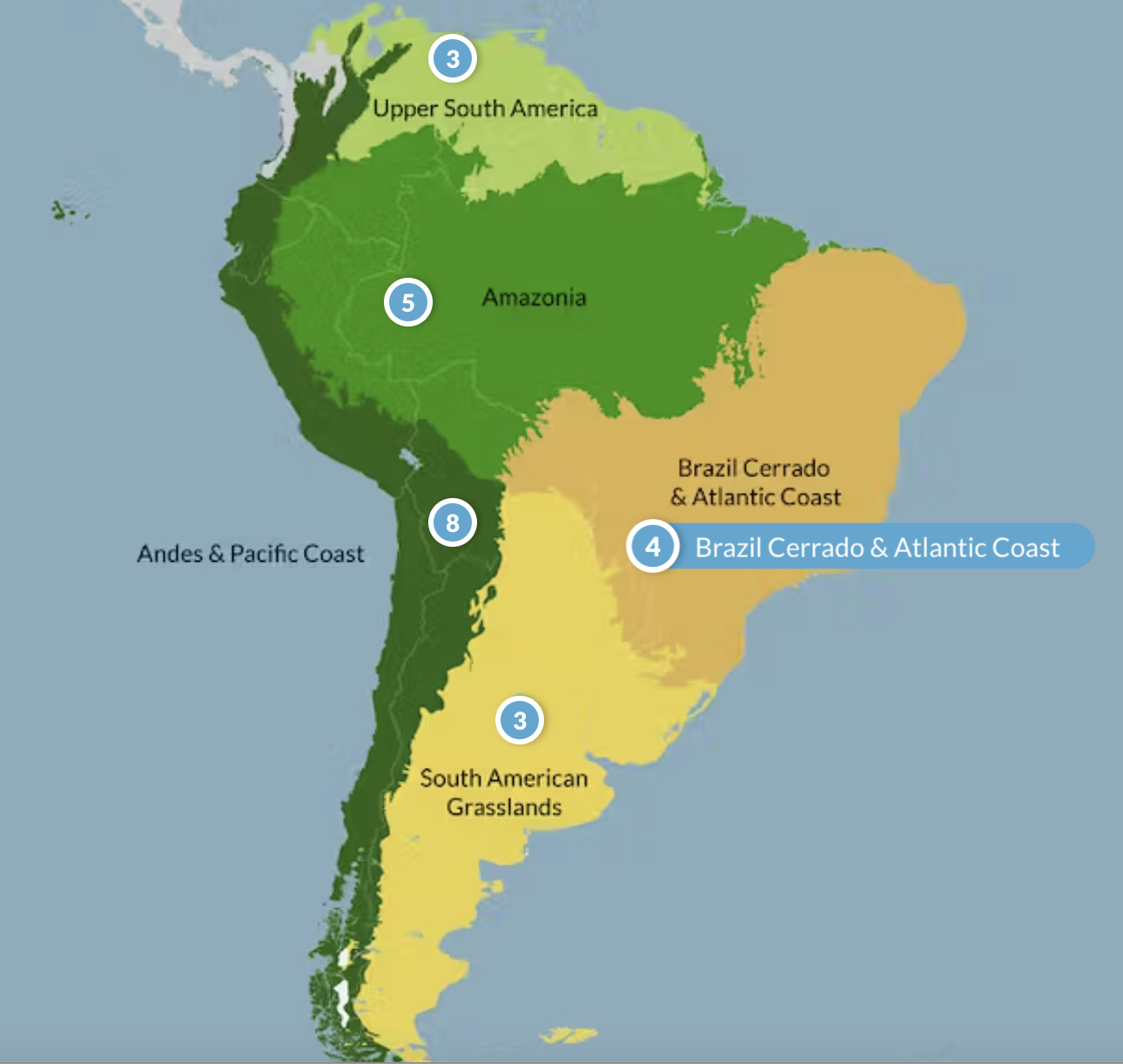
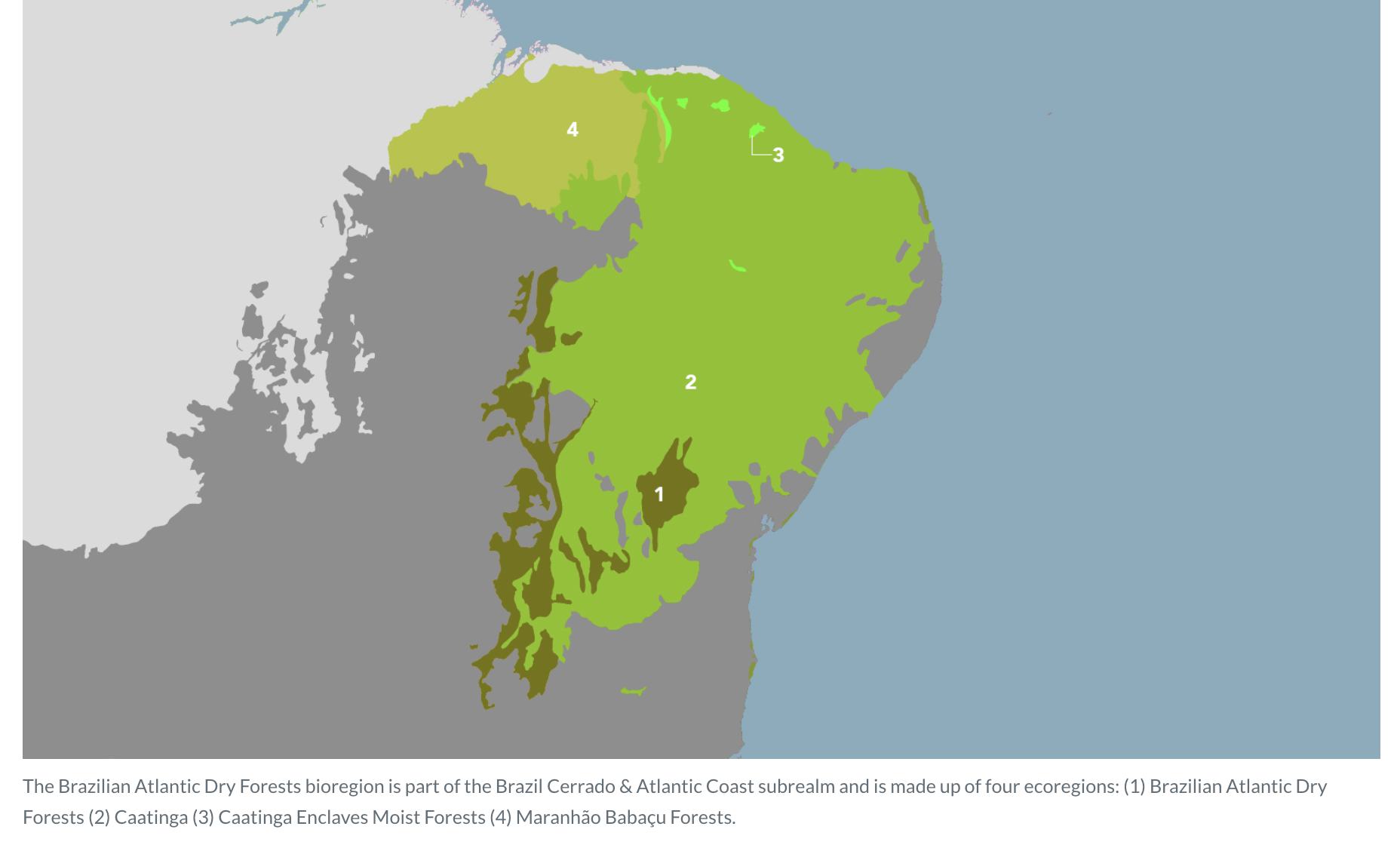
Here's a brief supplement on CECs and ecoregions, which were not explained above. An ecoregion is a geographical division with similar ecosystems, a finer unit than a bioregion.
The examples below illustrate this. The top image shows South America, where the Brazilian Cerrado and Atlantic Forest contain four bioregions. One of these, "The Brazilian Atlantic Dry Forests" bioregion, as shown in the bottom image, is further divided into four ecoregions.
This is the unit of an ecoregion. A CEC, furthermore, considers national borders within an ecoregion. The intention is that, because policies and so on differ by country, the state of biodiversity and the threats/risks to it also differ. Therefore, CECs are chosen as a framework for considering a project's Baseline, representing units that are **ecologically and politically largely homogeneous**. CECs average 76,500 square km in size.
<Calculating Net Biodiversity Contributions>
The Condition values for the project scenario and Baseline are calculated in a standardized form as described above. Subtracting Leakage and Buffer from these values yields the amount of Nature Credits generated. The specific quantification of Leakage is not yet provided, and the public consultation is seeking opinions on how to quantify it. Options such as direct measurement in a predefined leakage belt or setting default values for each activity type are presented here.
User Contribution Methods and Links to Other Initiatives
A distinctive feature of this framework is the provision of guidelines for end-users on the use of Nature Credits. Chapter "4 COMMUNICATIONS AND CLAIMS" offers concrete claim examples, with the key point being the positioning of Nature Credits use as **Beyond that commitment…**, after internal value chain actions have been taken.
“We have taken X, Y and Z steps to address our impacts on nature, from prevention to transformational actions to reduce the drivers of biodiversity loss. Beyond that commitment, we have purchased Nature Credits certified by an independent third-party auditor to the SD VISta Nature Framework to derisk our value chain and sustain our dependencies on nature. These Nature Credits represent the increase in biodiversity outcomes that would not have occurred without our financing of the project intervention. [Insert details of Nature Credits purchased here.] We will continue to invest both within and beyond our value chain until nature is visibly and measurably on the path of recovery toward a nature-positive world.”
Furthermore, "6 RELATED INITIATIVES AND CONCEPTS" outlines connections with the GBF (Global Biodiversity Framework) from CBD COP15, as well as SBTN (Science-based Target for Nature) and TNFD (Taskforce on Nature-related Financial Disclosures). As stated in the Nature Framework below, for the Nature Credits market to thrive, strong alignment with SBTN (which provides target-setting guidelines for companies) and TNFD (which is an information disclosure framework) is a significant consideration.
While Verra’s Nature Framework does not directly use the SBTN and TNFD frameworks, it was drafted to ensure it is aligned with existing global initiatives related to nature and biodiversity. The claims that can be made upon purchasing and retiring Nature Credits will be linked to the metrics outlined by the SBTN and TNFD.
Even without the concept of "Offset," the idea of making claims for Nature Credits use in the form of **Beyond that commitment…** relative to corporate targets and internal value chain reporting, feels like an exploration of a worldview similar to SBTi's BVCM (Beyond Value Chain Mitigation) in the carbon world.
This concludes our introduction to the current draft of Verra's Nature Framework for biodiversity Credits.
Our company profile document is available here for your reference.
Disclaimers:
This newsletter is not financial advice. So do your own research and due diligence.

If interested, please refer to this document. We have also previously held a seminar based on this document, so please contact us if you are interested. ↩
This may be unclear to those unfamiliar with the REDD Methodology discussions, but since many readers of this newsletter are likely more familiar with Carbon Credit and REDD discussions, this section is quoted directly. ↩